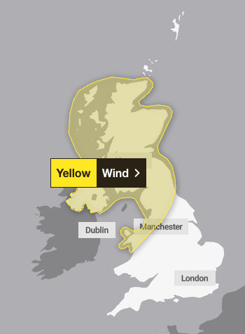
The Met Office has issued yellow weather warnings across large swathes of the UK over Easter, in what may be a disappointment for many hoping to enjoy the bank holiday weekend.
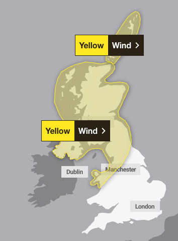
The warnings for wind are in place across Scotland, Northern Ireland and the north of England on Saturday and Sunday, with peak gusts of 80 to 90mph possible in certain exposed areas.
The Met Office warned that a spell of “very strong winds” would sweep across north-western parts of the UK on Saturday from 6pm, clearing to the North Sea by Sunday.
Described by the forecaster as a “rapidly deepening area of low pressure”, the exact intensity remains uncertain. Peak gusts of 50 to 60mph will be possible fairly widely, with 60 to 70mph in more exposed locations, the Met Office predicted.
There is a slight chance of some very strong winds across parts of Scotland, particularly in the West, where gusts of 80 to 90mph may be possible in exposed areas for a time.
The strong winds could cause some damage and travel disruption, with a “slight chance” of power cuts and an impact on mobile phone coverage.
While the winds are set to gradually ease throughout Easter Sunday, a second wind warning remains in place across the Orkney and Shetland Islands until the end of Sunday. The Met Office warned that the islands could see peak gusts of 60 to 70mph, with a slight chance of 75 to 85mph in some exposed areas for a time.
More generally, the United Kingdom can expect unsettled weather over the bank holiday, with spells of strong winds and rain moving across the country. Further south, there could be some drier and brighter interludes.
Met Office Deputy chief meteorologist Dan Holley said: “A significant cold plunge from Canada into the North Atlantic will impact our weekend weather, strengthening the jet stream and spinning up a deep area of low pressure towards the northwest of the UK on Saturday night. This will lead to a spell of very strong winds later on Saturday, and overnight into the morning of Easter Sunday.
“We have issued yellow warnings for wind for Scotland, Northern Ireland, and northern parts of both England and Wales for Saturday night and into Sunday, when a spell of very strong winds could cause disruption. Winds should gradually ease through Easter Sunday as the area of low pressure clears to the North Sea.
“Gusts are expected to reach 50 to 60mph widely, with 60 to 70mph possible in exposed locations. There is a chance of very strong winds in the west of Scotland, where gusts of 80 to 90mph could be possible. Due to the warnings this weekend, we recommend keeping an eye on our latest forecasts and as the week progresses.”

Good Friday will see a fair amount of cloud with some showery outbreaks of rain that will be heavy in places. There will also be some brighter interludes throughout the day. The Pennines will see blustery conditions, with Scotland and Northern Ireland experiencing cooler and brighter interludes with sunny spells and showers, which will be wintry on hills.
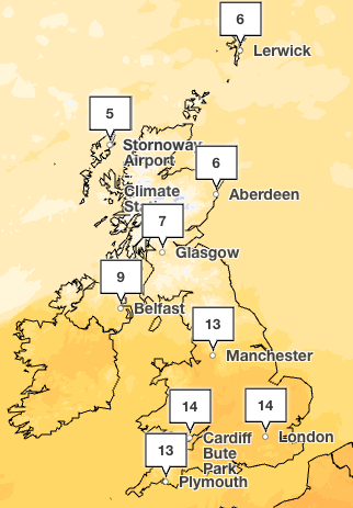
Temperatures will remain variable across the weekend, peaking at 14C across the South on Saturday, while cooler temperatures in the single digits are expected further north.
It comes after the UK experienced its joint tenth warmest March in a series dating back to 1884, according to provisional statistics. With a mean temperature of 7C, March 2026 is tied with last year as the joint tenth warmest on record. The warmest March for the UK remains 1938.
Wales saw its joint fourth-warmest and England its joint sixth-warmest March, with both nations experiencing their warmest March since 2017.
Met Office weather forecast for the week ahead
Wednesday
A band of wind and rain across north-west Scotland will gradually move south-eastwards today, perhaps reaching northern England and north Wales by evening. Ahead of this, any early fog clearing but a cloudier day overall than Tuesday.
Overnight
The band of rain will continue moving south-eastwards, but gradually petering out. Dry with clear spells either side of this with a widespread frost developing across the North.
Thursday
Cloudy with patchy drizzle at first in the far South East. Otherwise dry with some sunny spells, although rain arriving into the North West later. Temperatures near average for early April.
Outlook for Friday to Sunday
Rather unsettled for the Easter weekend with spells of strong winds and rain moving across the country. Some drier and brighter interludes developing, especially across the South East.
22 million cars set to hit roads despite fuel price rises as Easter getaway begins
Galeforce winds expected to cause disruption over Easter weekend
We are so close to eradicating polio – the UK cannot afford to let progress slip
‘Build up some delayed courage’ and grab Strait of Hormuz, Trump tells nations
Final day as BBC director-general for Tim Davie
Animal crossing: National treasure spotted at Beatles’ landmark